Huaraz – Peru
Huaraz is the international mountaineering capital in Peru, situated in the Rio Santa Valley that is bound by two major ranges, the Cordillera Blanca to the east and the Cordillera Negra to the west. Locals refer to this area as El Callejon de Huaylas and the city of Huaraz lies at 3,065 meters above sea level (11,518 feet) in the southern third of the valley. The snowy peaks from the Cordillera Blanca tower high above the valley, rising into the deep blue Andean sky, which gives the department of Ancash its well suited name of Blue in their Quechua language. The Cordillera Negra namesake comes from the range not having any snow covering it, but these mountains were previously glaciated as well. This cordillera is not as popular as the Cordillera Blanca although its peaks are above 4,200 m and its highest peak is at 5,200 m. Some of the more impressive vistas of the Cordillera Blanca are to be had during sunset from the vantage points along the crest of the Cordillera Negra.


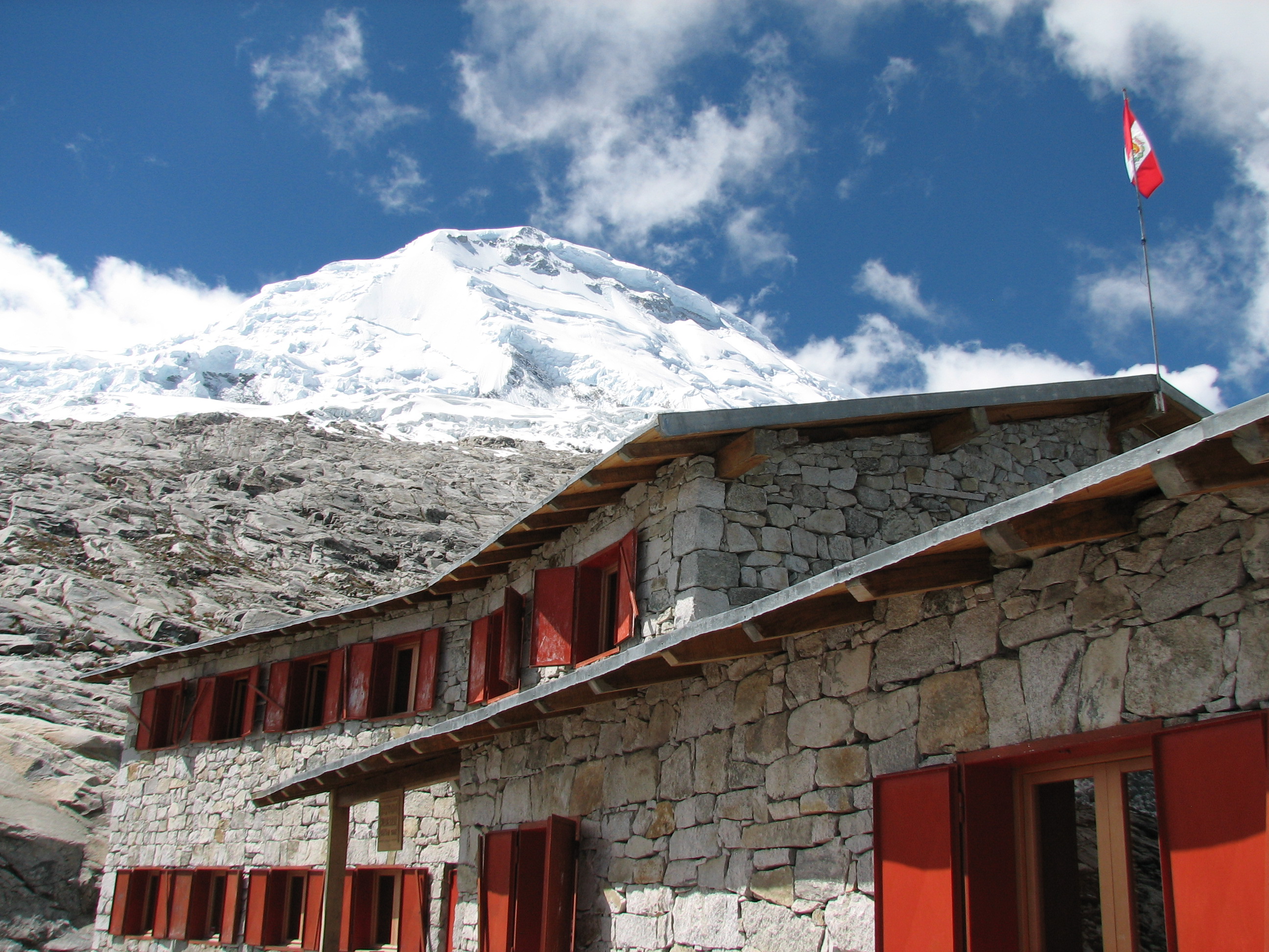
Huaraz is the entry point to the Cordillera Blanca; it is one of the most visited cities in Peru particularly by trekkers and mountaineers. The Cordillera Blanca is the second highest mountain range in the world, after the Cordillera del Himalaya. Huascaran is the 4th highest mountain peak in South America; and Huascaran is the highest peak in Peru with an elevation of 6,768 meters (22,205 feet). The northern part of the range has the classic pyramid-shaped ice encrusted and fluted summit of Alpamayo at 5,947 m (19,511 feet) considered to be by many the most beautiful mountain in the world! The main complex of glacial-covered summits overlooking the town of Huaraz is called Ranrapalca. A high elevation near vertical big wall called La Esfinge (Torre de Paron), which is near 1,000 meters high, has several routes of very difficult ratings that also include sections of aid climbing. La Esfinge is located NW of Lago Paron, and its south facing, its also located to the opposite side of the valley, from El Nevado Huandoy. Most of the 6,000 m plus peaks require several days to climb, these routes are technical, and they can be closed out due to bad weather. The peak climbing season happens during the winter dry period in July and August. The book “Classic Climbs of the Cordillera Blanca Peru” by Brad Johnson is one that we recommend. The Cordillera Blanca has 135 minor peaks above 5,000 m and 34 peaks that rise above 6,000 m (listed at end of post).
Huascaran National Park was created to protect the entire area of the Cordillera Blanca in 1960, but it didn´t become official until 1975. In 1985 it was declared a World Heritage Site by UNESCO. The park is also meant to protect its flora and fauna of what is considered a high tropical mountain with unique species such as the famous Puyas de Raymondi (considered the largest bromeliad in the world) and Quenuales (a reddish papery barked small tree). Another endemic and endangered species are the Oso de Anteojos (the bear with glasses or commonly known as el Oso Andino), the Andean Condor, and small rare deer. For the most current information and regulation visit SERNANP (Servicio Nacional de Areas Protegidas por el Estado), visitors should register at the park office and pay a fee. The Asociacion de Guias de Montañas del Peru or simply Casa de Guias in Huaraz, tucked away in the Plaza Ginebra, has all the information necessary to visit the park; there you could also find maps and guide books for the different trekking areas.
Other points of attraction from Huaraz are; the Wilcahuain Ruins from the Wari culture (a fifteen minute taxi ride from Huaraz), the archaeology site of Chavín de Huantar, and the popular Monterrey Hot Spring. The majority of the hot springs of the region has formed along the west range front fault, to the Cordillera Blanca, and they are found to the north of Huaraz. The Pomabamba and Quercos hot springs are found along the eastern side of the range. In somewhat related geography hot springs are also found scattered about the Cordillera Huayhuash, which is the next major high range to the south. The hot springs of Monterrey and Chancos are the most widely known and visited; for more information and exact location see the Hot Springs of the Andes guidebook.


The deep blue glacial lakes that one can explore, contrast with the glaciers of the Cordillera Blanca, and the most popular or visited of these is Lago Llanganuco. Farther north, east of the town of Caraz, the more remote but similar sized Lago Paron at 4,200 m of elevation has the most impressive turquoise water color, and is overlooked by the spectacular north face of Nevado Huandoy, the second highest summit group in the range.
There are plenty of hotels and hostels in Huaraz; we usually stayed at El Tumi Hotel because its proximity to the main plaza. Restaurants carry well prepared Peruvian food that you could find at a set menu at a very affordable price. Many other restaurants offer international food given the fairly large expat community and taste of international travelers. Our favorite is Creperia Patrick along Main Street for dinner, and his most delicious crepes. Huaraz also has the upcoming quality craft brewery Sierra Andina, be sure to try their beers.
The Ancash department and Callejon de Huaylas in particular are prone to natural disasters such as landslides caused by the overflow of mountain lakes, and earthquakes that occur in this region, or sometimes a mixture of avalanches, earthquakes, and landslides will hit the area. The last three natural disasters are the most remembered; one occurred in 1941 when Palcacocha Lake overflowed into Huaraz killing 5,000 people. In 1962 an avalanche from Huascaran destroyed the town of Ranrahirca killing 4,000 people, and in 1970 when a massive earthquake at 7.8 magnitude in the Richter scale hit the Pacific Ocean causing a huge avalanche to hit the city of Yungay and completely buried it, killing 18,000 people there, 30,000 people died in Huaraz and 70,000 people died in central Peru. To this day this is the worst natural disaster registered in Peruvian history and many nationals travel to the Yungay memorial in remembrance to this day.
Peaks above 6,000 meters:
- Artesonraju at 6,025 m
- Caraz I at 6,025 m
- Caraz II at 6,020 m
- Chacraraju Este 6,001 m
- Chacraraju Oeste 6,112 m
- Chinchey 6,222 m
- Chopicalqui 6,354 m
- Contrahierbas 6,036 m
- Copa Norte 6,173 m
- Copa Sur 6,188 m
- Chinchey 6,222 m
- Huandoy Norte 6,395 m
- Huandoy Sur 6,160 m
- Huandoy Este 6,000 m
- Huandoy Oeste 6,356 m
- Huascaran Norte 6,654
- Huascaran Sur 6,768 m
- Hualcan Este 6,125 m
- Hualcan Oeste 6,104 m
- Huantsan 6,395 m
- Huantsan Norte 6,113 m
- Huantsan Oeste 6,270 m
- Palcaraju 6,274 m
- Palcaraju Oeste 6,110 m
- Palcaraju Este 6180 m
- Pucaranra 6,147 m
- Pucajirca Norte 6,046 m
- Pucajirca Oeste 6,039 m
- Pucajirca Este 6,046
- Pucajirca central 6,014 m
- Quitaraju 6,040 m
- Ranrapalca 6,162 m
- Santa Cruz Grande 6,259 m
- Tocllaraju 6,032 m
Do connect with us:
ResearchGate: James M. Wise
Author´s page: James M. Wise
Photography page: JamesM.Wise.com
Twitter: JamesM_Wise
Facebook: Yanira K. Wise
Author´s page: Yanira K. Wise
Instagram: yanirak.wise
Twitter: @YK_Wise
Facebook for South America to the World
South America seems to refuse to show its inexhaustible creative force.


