Deformation in the Cordillera de la Sal and surrounding the Salar de Atacama, Chile
The hyper-arid contorted mountain range lying just west of San Pedro de Atacama in northern Chile has part of the range classified as Valle de la Luna National Park. The importance of this mountain range, apart from its scenic landscapes and spectacular views eastwards towards the chain of active volcanoes, comes in the understanding of Chilean tectonic events and the actual formation of the large Salar de Atacama. A few highlights of the geology are worth considering with two main objectives kept in mind- the timing of the Incaic and Quechua shortening events.
The Salar de Atacama lies centered at 23.35 degrees south latitude, and has a surface elevation of 2,300 meters above sea level. The salar and basin is 115 km long by 61 km wide, and it is slightly NNE-trending for the basin long axis. The east margin is bounded by flank deposits of the southern Central Volcanic Zone, the edge of which culminates in numerous spaced stratovolcanoes with summits over 5,000 meters. The west margin of this remarkable large basin is bounded by the Cordillera de la Sal. The rather dirty little flat town of San Pedro de Atacama makes a dot in the northern part of the basin. The paved route from Calama to San Pedro de Atacama goes over the northern end of the Cordillera de la Sal.

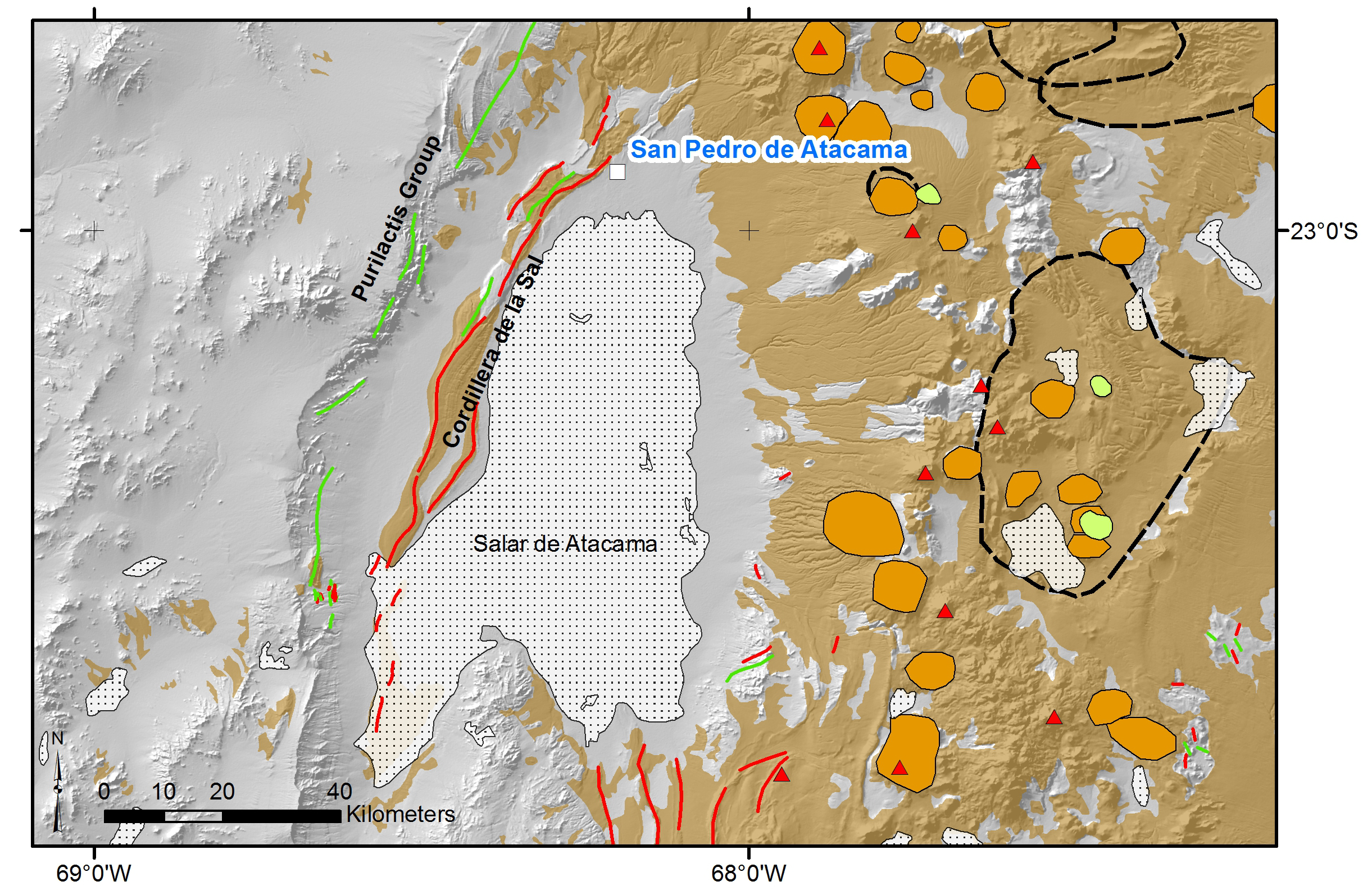
DEM map showing the Salar de Atacama and the Cordillera de la Sal bounding its west margin. Beige areas are Cenozoic volcanic rocks, orange areas marks stratovolcanoes, light green areas are rhyolitic domes, dashed black lines are caldera outlines, red triangles are active volcanoes, green lines are syncline axes, and red lines are anticline axes. The Cordillera de la Sal formations are also shown in beige, although they really are not primary volcanic rocks.
Tectonic setting
Flint et al. (1993) described the tectonic setting the Salar de Atacama basin as passing through several different configurations as based on the relative position with the magmatic arc through geologic time. Early deposits and history have the basin in the backarc setting up to the Eocene time when the large porphyry copper deposits were forming along the Domeyko Cordillera to the west, and particularly that of Chuquicamata deposit near Calama. Mpodozis et al. (2005) provided detailed descriptions of the folded older section of the Purilactis Group that record Paleocene-Eocene deposition of the older basin fill. Magmatic activity moved eastward in the late Oligocene and during the Early Miocene was accompanied by extensional tectonics to the east, and transpressional faulting from the Atacama fault zone to the west (Scheuber and Andriessen, 1990; Brown et al., 1993), and likewise transpressional deformation to the southeast of the basin (Kuhn, 2002). The southeast basin bordering structures have young geomorphology, suggested by the structures making positive topography, including the NS-striking thrust that defines a ridge effectively blocking in Lake Miscanti. Flint et al. (1993) classified the Atacama basin as being in the forearc setting for the late Cenozoic, however, this is not in the traditional sense as seen along many subduction forarc basins because of its elevated or subaerial environment and highly segmented or disrupted pattern related to the oblique component of deformation. The Oligocene sequences in the Salar de Atacama basin were suggested by Flint et al (1993) and Rubilar et al. (2015) as recording growth sedimentation during extension.
Constraints on early Cenozoic deformation (maybe the Incaic event)
The Purilactis Group in the range west of the Cordillera de la Sal marks large-scale folding that Flint et al. (1993) generally attributed to the Incaic shortening. Their graph in Fig. 8 of their paper estimates a halt to basin subsidence at 40-35 Ma, labelling this the Incaic shortening time. Although, see our recent post Timing of the Incaic Deformation where said tectonic event in Peru is now considered to be older than 46 Ma. The timing of folding affecting the Purilactis Group seems to be younger than 44 +/- 1 Ma from a sample taken near the top of the section by Reutter et al. (1991) and dated by the 40Ar/39Ar method. Some amount of the folding predates the deposition of the overlying Paciencia Group. It is possible these folds experienced additional closure or tightening from superimposed younger folding that affects the Paciencia Group. Should a folding event in northern Chile that appears to be at least 11 million years younger than the Incaic event in Peru still be called the same thing? Probably not.
Mpodozis et al. (2005) provided additional studies of the section west of the Cordillera de la Sal, finding older late Cretaceous compression deformation (refined by Bascuñán et al., 2015 to peak times of 107 and 79 Ma; see also Arriagada et al., 2006), and followed by younger deposition of the Loma Amarilla Formation, citing ages of 42.2 +/- 0.9 Ma and 43.8 +/- 0.5 Ma (this latter 40Ar/39Ar date on biotite from sample Pu-1 by Hammerschmidt et al. 1992 from the southwest side of Salar de Atacama, described as an andesitic lapilli tuff). Mpodozis et al. (2005) miss-reported the location of sample Pu-1 in their Figure 5, showing it 7.7 km too far north of the coordinates provided by Hammerschmidt et al. (1992). Mpodozis et al. (2005) concluded that the Loma Amarilla Formation was syn-Incaic, and gave a range of 45 to 35 Ma. This is a ten million year period of compressional deformation in northern Chile; whereas the ~pre-46 Ma regional contractional deformation in Peru likely happened in less than 3 million years. From the Peruvian type area for the Incaic II contraction event, the upper limit on deformation is placed 45.78 +/- 0.31 Ma (Noble et al., 2005; Noble and Wise, 2016). Whatever deformation happened around the Salar de Atacama reported by Mpodozis et al. (2005) is not the same as the deformation in Peru.
Timing of the Quechua event
The main formation of interest, for the tectonics that resulted in the present geomorphology of the range, crops out in the Cordillera de la Sal and is called the Paciencia Group (a.k.a. San Pedro Formation), which was deposited over the Oligocene-Miocene time (Flint et al., 1993). This formation is essentially part of the early basin fill of the Salar de Atacama, and as being of such it records thick horizons of evaporite deposits, much like the modern depositional setting of the basin. A trip through Valle de Luna to see the folded rocks in the Cordillera de la Sal is a journey through unsteady tectonic conditions that permitted periods of extension to neutral stress and then marked interruptions of this prolonged condition by short intervals of intense rock deformation.
Flint et al. (1993) marked the end of the Paciencia Group deposition during the deformation of the Quechua 1 event, at about 17 million years ago. In Peru, the Quechua events were defined to have three separate periods of folding; such that the deformation in the Salar de Atacama and the Paciencia Group corresponds to the earliest event in the early Miocene. The timing is rather open in the Cordillera de la Sal, with the major angular unconformity being overlain by Late Miocene to Pleistocene gravel. Flint et al. (1993) place the upper limit on folding in the Paciencia Group from an old K-Ar age by Ramirez (1979), which was taken from the overlying San Bartolo Group (reported- see below). K-Ar ages in general are prone to larger errors and other issues that can shift apparent age from thermal resetting or mineral alteration which leads to argon loss.
Ramirez (1979) original age of 17 +/- 2 Ma was ran on the mass spectrometer in the Instituto de Geocronologia y Geologia Isotopic de Buenos Aires, which is not exactly well known for making internationally acceptable results. Unlike what Flint et al. (1993) reported with this sample being from the San Bartolo Group, Ramirez (1979) had sample RG-169 from the Grupo Volcanico Jorquencal-Machuca. Flint et al. (1993) [and the journal Bulletin of the Geological Society of America] glossed over the details of this age while at the same time used it for constraining major structural events in northern Chile. Instead, Ramirez (1979) gave a younger age of 7 Ma (sample RG-162 from tuff in the San Bartolo Group). The 17 Ma age was from a biotite mineral separate taken from a dacite unit. Its context, if any, with respect to the Paciencia Group has never been described. This sample comes from about 25-km northeast from the nearest folded strata in the Cordillera de la Sal. Flint et al. (1993) stated that this lava is at the base of the San Bartolo Group, but they also miss-reported the formation name.

Picture of the marked angular unconformity with the folded San Pedro Formation beneath the ca. 9-8 Ma Vilama Formation (Evenstar et al., 2016), which comprises an overlying unit that is relatively flat lying to gently folded gravel with lesser interbedded horizons of tuff. Absolute bracketing of the folding event is <28 Ma and > 9.45 Ma. Previous interpretations of the event being near 17 Ma are not supported by the context of the limited regional data. Photo is taken while standing above the Vilama Formation; the angular unconformity is below the escarpment. The reddish rocks belong to the San Pedro Formation.

Of course, the lower age for timing of the folding in the Cordillera de la Sal is even more poorly constrained, a fact that Flint et al. (1993) acknowledged. We are left wondering what were the duration of folding and its exact timing? Does it really correlate to the Quechua 1 event of Peru?
The folds in the Cordillera de la Sal are NNE-trending, and mainly mark a breached large-scale anticline running the length of the range. The evaporite horizons, comprised of halite, which is rock salt, likely aided the folding, providing easily deformed layers upon which the rock layering could squeeze along as the rocks were compressed. The structural contribution from salt domes or diapirs during the time of folding remains poorly documented. That the layering in the Paciencia Group comes in parallel to one another suggest relatively passive depositional conditions, or neutral stress during deposition. A brief period of contraction to shorten the basin with folds and faults, and then return to near neutral conditions in the present day to permit the wide expanse of flat evaporates to accumulate. The timing of the folding remains very open or unconstrained, being less than 28.6 +/- 6 Ma (from Travisany 1979 in Flint et al., 1993; note the huge errors on this age, making it also unreliable). The only hard timing of this folding event is that it pre-dates the angular unconformity with the overlying late Miocene Vilama Formation, which has a date of 9.45 +/- 0.03 Ma from the Artola Ignimbrite at an outlier some 34 km to the west of the Cordillera de la Sal (Salisbury et al., 2010).

Summary
The Salar de Atacama is illustrative of alternating extensional and contractional tectonism in the Andes. The age constraints of deformation here should not be directly correlated with Peru events for the Incaic, and the timing of the possible Quechua event needs to be greatly improved to determine if age equivalency between Peru and Chile exists. Previous studies rely too much on old and fairly unreliable K-Ar dates with poorly constrained geologic context while making tectonic interpretations.
James M. Wise, April, 2018
References
Arriagada, C., Cobbold, P.R., and Roperch, P., 2006, The Salar de Atacama basin: a record of Cretaceous to Paleogene compressional tectonics in the Central Andes: Tectonics, v. 25, TC1008.
Bascuñán, S., Arriagada, C., Philippus Le Roux, J., and Deckart, K., 2015, Unravelling the Peruvian Phase of the Central Andes: Stratigraphy, sedimentology and geochronology of the Salar de Atacama Basin (22° 30-23° S), northern Chile: Basin Research, p. 1-28.
Brown, M., Diaz, F., and Grocott, J., 1993, Displacement history of the Atacama fault system 25°00’S-26°00’S, northern Chile: Geological Society of America Bulletin, v. 105, p. 1165-1174.
Evenstar, L.A., Hartley, A.J., Archer, S.G., and Neilson, J.E., 2016, Climatic and halokinetic controls on alluvial-lacustrine sedimentation during compressional deformation, Andean forearc, northern Chile: Basin Research, v. 28, p. 634-657.
Flint, S., Turner, P., Jolley, E.J., and Hartley, A.J., 1993, Extensional tectonics in convergent margin basins: An example from the Salar de Atacama, Chilean Andes: Geological Society of America Bulletin, v. 105, p. 603-617.
Hammerschmidt, K., Döbel, R., and Friedrichsen, H., 1992, Implication of 40Ar/39Ar dating of Early Tertiary volcanic rocks from the north-Chilean Precordillera: Tectonophysics, v. 202, p. 55-81.
Kuhn, D., 2003, Fold and thrust belt structures and strike-slip faulting at the SE margin of the Salar de Atacama basin, Chilean Andes: Tectonics, v. 21, 8:1-17.
Mpodozis, T.C., Arriagada, C., Basso, M., Roperch, P., Cobbold, P., and Reich, M., 2005, Late Mesozoic to Paleogene stratigraphy of the Salar de Atacama Basin, Antofagasta, Northern Chile: Implications for the tectonic evolution of the Central Andes: Tectonophysics, v. 399, p. 125-154.
Noble, D.C., and Wise, J.M., 2016, Timing of Incaic deformation and subsequent erosion, middle Eocene volcanism, and plutonism in central southern Peru with implications for mineralization: Sociedad Geológical del Perú, XVIII Congreso Nacional de Geológia, Resumes Extendidos, 4 p.
Noble, D.C., Vidal, C.E., Angeles Z., C., Wise, J.M., Zanetti, K.A., and Spell, T.L., 2005, Caldera-related ash-flow tuff of Paleocene age in central Peru and its significance for late Cretaceous and Paleocene magmatism, sedimentation, and tectonism: in Arce-Helberg, J.E., ed., Volumen Especial No. 6 Homenaje al Alberto Giesecke Matto, Sociedad Geológica del Perú, Lima, p. 127-140.
Ramirez, C. F., 1979, Edades potasio-argon de rocas volcanicas en la zona de San Pedro de Atacama-El Tatio, Region de Antofagasta: Actas, II Congreso Geologico Chileno, Arica, v. 2., p. F31-F45.
Rubilar, J.F., Becerra, J., and Arriagada, C., 2015, Structure of the Cordillera de la Sal: A key tectonic feature for the Oligocene-Neogene evolution of the Salar de Atacama basin, Central Andes of Northern Chile: XIV Congreso Geologico Chileno, La Serena, p. 133-136.
Reutter, K.J., Schreubar, E., and Helmcke, D., 1991, Structural evidence of orogen-parallel strike slip displacement in the Precordillera of northern Chile: Geologische Rundschau, v. 80, p. 135-153.
Salisbury, M.J., Jicha, B.R., De Silva, S.L., Singer, B.S., Jiménez, N.C., and Ort, M.H.,
2010, 40Ar/39Ar Chronostratigraphy of Altiplano-Puna Volcanic Complex Ignimbrites
Reveals the Development of a Major Magmatic Province: Geological Society of
America Bulletin B30280.1
Scheuber, E., and Andriessen, P.A.M., 1990, The kinematic and geodynamic significance of Atacama fault zone, northern Chile: Journal of Structural Geology, v. 12, p. 243-257.
Wilkes, E., and Gorler, K., 1994, Sedimentary and structural geology of the Salar de Atacama depression: Tectonics of the Southern Central Andes, Springer-Link, p. 171-188.
Do connect with us:
ResearchGate: James M. Wise
Author´s page: James M. Wise
Photography page: JamesM.Wise.com
Author´s page: Yanira K. Wise
South America seems to refuse to show its inexhaustible creative force.


