TIMING OF THE QUECHUA 1 CONTRACTIONAL EVENT IN CENTRAL PERU
An intense period of folding slammed the rocks of central Peru after a prolonged period of little deformation during most of the Oligocene. Two key 40AR/39Ar dates are described here that place brackets on the timing of the Quechua 1 event. The Quechua 1 event was the second most significant period of folding and deformation to happen in Peru. Both of these ages were made on the mass spectrometer at the University of Las Vegas, Nevada that is overseen by Terry Spell and Kathleen Zanetti. Both analyses used the Fish Canyon tuff sanidine standard.
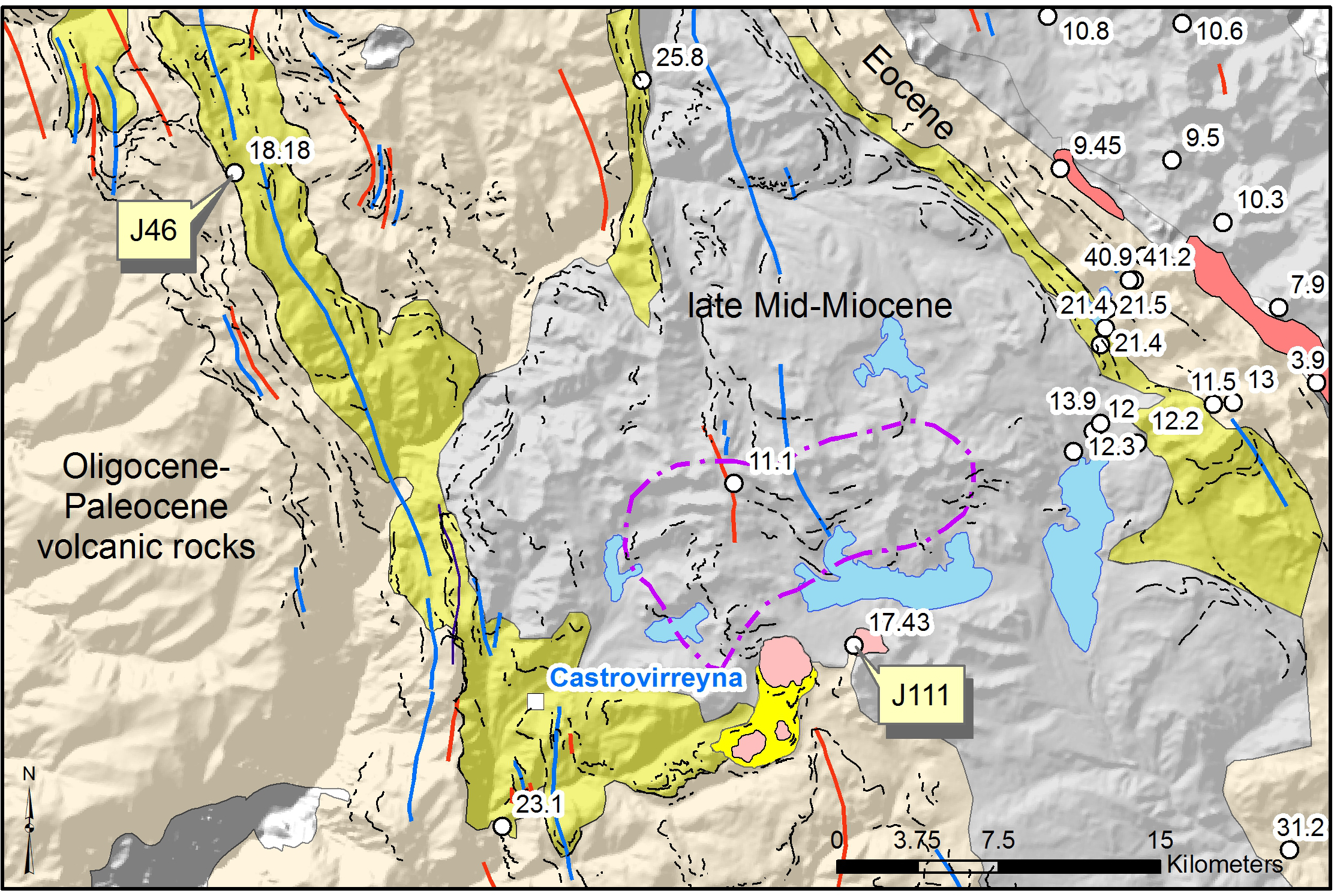
The older limit on the Quechua 1 deformation comes from a welded ash-flow tuff unit (Castrovirreyna Formation) in central Peru- from a steeply dipping bed located well northwest of the Castrovirreyna mining camp. The source caldera for this widespread tuff unit remains undiscovered. Samples J46 is located at 75.42834°W, 13.045352°S (see the geology map in this post). The sample yielded an isochron age of 18.18±0.06 Ma from a separate of granophyrically crystallized groundmass. A plateau age of 18.23±0.09 Ma, using 67.8 percent of the released 39Ar, is remarkable close to the isochron age. The folding that tilted this bed 45 degrees towards the east and that made the regional Castrovirreyna synclinorium developed after this time of eruption and deposition of the tuff. This lower limit on the timing of the Quechua 1 event is considered highly reliable.

From just southwest of the Castrovirreyna mining camp is a set of dacite domes. The western dome complex has a flat-lying basal tuff ring. These basal deposits have an angular unconformity with the folded sequence of volcanic rocks from which sample J111 is part of (location 75.17006°W, 13.24257°S). The east dacite dome gave a biotite separate preferred plateau age of 17.73±0.12 Ma (84.1 percent of the released 39Ar). The sample also has an isochron age of 18.34±0.13 Ma (MSWD of 0.99 and a 40Ar/36Ar ratio of 298±7.5). The eastern dome is petrographically similar to the west dome, and both probably have similar timing of eruption of the west dome complex that pins the angular unconformity (location 75.191°W, 13.261°S) and it possibly makes the upper limit on the Quechua 1 event. That these domes define circular pattern in map view and have low-angle bedding dips in the basal tuff ring indicate that they remain upright; if they had been tilted then they would be shown edgewise, making a lens-shaped map pattern. The angular unconformity has an open anticline below it to the south.
The above age on sample J111 combined with geological contact relations of the dacite dome complex represents perhaps the best upper limit on the Quechua 1 event made to date, however, some additional comments are important. First, the location with the angular unconformity is not easily accessible or visible from the Castrovirreyna road. Second, the actual contact has not been walked; it was noted through air photo interpretation. Furthermore, the contact between the basal tuff ring and the underlying folded section is mostly covered by tundra/grass. Third, some folding perhaps happened after eruption of the dacite dome; the tuff ring appears to be relatively flat lying, however, the dome is near the hinge of the anticline in the underlying folded section which could imply it is accidentally located in a spot where the folding would not be evident. If the context of J11 does not work out as constraining the upper limit on the Q1 event then the age would include these domes in the Castorvirreyna Formation and extend the duration of its deposition.
The upper age limit on the Quechua 1 event is less easily constrained because of a major reduction in the amount of volcanism going into the middle Miocene, resulting in fewer deposits to date the folding. In the area examined here, at Castrovirreyna, volcanism did not pick up again until around 12 Ma with the eruption of the andesite flows in the Caudalosa Formation.
These western central Peru dated locations bracket the timing of the Quechua 1 contractional event to be less than ~18.2 Ma and older than ~17.7 Ma, happening in less than 0.5 million years!
Additional samples scattered throughout central Peru generally confirm the timing outline from the two dated samples, but have wider errors from K-Ar dating method, or lesser geological context. McKee and Noble (1982) K-Ar dates gave the Quechua 1 event as happening between 21.5 Ma and 12 Ma. The sequence of volcanic rocks from which the older age of 21.5 Ma comes from is an area called Chonta Pass, located east of Laguna Choclococha. The volcanic section here has units that lie parallel to one another with strike length approaching 200 km, as exposed on the eastern limb of the Castrovirreyna synclinorium. The older part of this concordant section dates back to the middle Eocene, which suggests essentially no tilting or important deformation happened between ~45 Ma up until after 21.5 Ma. At Chonta Pass (75.04907°W, 13.0811°S), the same volcanic section with the Tantara, Sacsaquero, and Castrovirreyna Formations are tilted to near vertical. The K-Ar age from sample 4 from McKee and Noble (1982), taken from a tuff cropping out by Laguna Pultocc, gave 21.4±0.6 Ma, which is ~3 million years older than the result described above for sample J46.
The geology map shown in this post illustrates rather complex volcanic units and the majority of the age constraints cluster in the northeast corner of the map near Chonta Pass. The west flank of the Castrovirreyna synclinorium has many questions on the geology that requires more radiometric dating. Decades have passed since McKee and Noble (1982) study in the region; essentially nobody is researching, mapping, and dating the central Peruvian geology once outside of the areas of active mining. Noble et al. (1999) expounded upon the hypothesis that tectonism-magmatism-mineralization has distinct ordered arrangements in Peru. Determining the timing of deformation events must be done before drawing conclusions about its possible contributions to the crustal release of magmatic-hydrothermal metal deposits.
The Quechua 1 event was reported by Mégard et al. (1984) as being at about 17.5 Ma from K-Ar ages on the early Miocene section in the Ayacucho intermontane basin. In contrast, my mapping and work reported in my 2004 dissertation and in Wise and Noble (2006) on the geology of the Ayacucho region demonstrated that the early Miocene section, while overlapping the general time of the Quechua 1 event, was not accompanied by any folding. The ages reported in Mégard et al. (1984) were equivocal for pinning the timing of the Quechua 1 event despite the cited age of 17.5 Ma matching what the mid-point of the folding event really comes out to farther to the west where the rocks were strongly folded. There are more details to the Ayacucho intermontane basin section for why Mégard et al. (1984) came to the miss-leading conclusion about the presence of Quechua 1 event in the section, but fundamentally the new mapping and data provided better controls on the complex volcanic geology.
The Quechua 1 event had the most impact on the volcanic section in the Cordillera Occidental of central Peru, forming the regional Castrovirreyna synclinorium. This deformation is domainal, developed to the west of the Coastal batholith (Wise et al., 2014). Locally, the Quechua 1 event folded the Calipuy Group in the Cordillera Negra of northern Peru. It did not cause major folding at Ayacucho as previously reported in Mégard et al. (1984). It almost certainly was responsible for making the major folds in the red beds of the San Jeronimo Group in the Cusco intermontane basin (Wise and Noble, 2016). It also deformed volcanic sections in the Cordillera Occidental of southern Peru. It may be correlated to major folding at the Salar de Atacama in northern Chile. And some evidence of the event may be in the folded volcanic rocks of the central Cordillera as far south as Santiago, Chile. It remains to be seen with additional dating if all of these areas were exactly coeval or whether there was variation in the timing and duration depending on location.
The 0.5-million year duration on the timing of the Quechua 1 event, perhaps centered at about 17.9 Ma, is remarkably short, but then the younger Quechua 2 event was likewise very rapid, happening in less than 0.3-million years (Wise, 2004; Wise et al., 2008). From the older major deformation of the Incaic contraction in the early Eocene, to late Eocene through Oligocene quiescence, rapid shortening during the Quechua 1 event, followed by neutral stress to tension near Ayacucho, then a pulse of deformation during the Quechua 2, and then again locally during the Quechua 3 event (Wise, 2007), it is clear that rock strain in the Peruvian Andes is a discontinuous process. The structural development of the Peruvian Andes happened during brief intense periods of deformation.
While a causative explanation of major regional folding during the Incaic II deformation event may be linked with major plate vector changes in the Pacific, the folding of the Quechua events (1, 2, and 3) appear to require other considerations that most commonly are considered a function of the subducting slab dip angle. The regional magmatic lull that happened following the Quechua 1 event is consistent with subduction reconfiguration to a shallower dip.
James M. Wise, June 2018

References
McKee, E.H., and Noble, D.C., 1982, Miocene volcanism and deformation in the western Cordillera and high plateaus of south-central Peru: Geological Society of America Bulletin, v. 93, p. 657-662.
Mégard, F., Noble, D.C., McKee, E.H., and Bellon, H., 1984, Multiple pulses of Neogene compressive deformation in the Ayacucho intermontane basin, Andes of central Peru: Geological Society of America Bulletin, v. 95, p. 1108-1117.
Noble, D.C., Wise, J.M., and Vidal, C.E., 1999, Episodes of Cenozoic extension in the Andean orogen of Peru and their relation to compression, magmatic activity and mineralization: in Macharé, J., Benavides, V., and Rosas, S., eds., Volumen Jubilar No. 5, 75 Aniversario Sociedad Geológica del Perú, Lima, p. 45-66.
Wise, J.M., and Noble, D.C., 2016, The post-Incaic II Cusco intermontane basin: Sociedad Geológical del Perú, XVIII Congreso Nacional de Geológia, Resumes Extendidos, 4 p.
Wise, J.M., Noble, D.C., Vidal C.E., and Angeles Z., C., 2014, Structural and stratigraphic relations between the rigid Coastal Batholith Block and the Highland Mobile Belt and their relation through time to magmatism and caldera formation. Sociedad Geológical del Perú, XVII Congreso Nacional de Geológia, Resumes Extendidos, 6 p.
Wise, J.M., Noble, D.C., Spell, T.L., and Zanetti, K.A., 2008, Quechua II contraction in the Ayacucho intermontane basin: Evidence for rapid episodic Neogene deformation in the Andes of central Perú: Journal of South American Earth Sciences, v. 26, p. 383-396.
Wise, J.M., 2007, Tectono-stratigraphic history of the Huancayo intermontane basin, central Peru: Boletín de la Sociedad Geológica del Perú, v. 102, p. 63-78.
Wise, J.M., and Noble, D.C., 2006, Early Miocene bimodal volcanism and syn-extensional deposition: the Larampuquio Formation, Ayacucho intermontane basin, central Perú: Boletín de la Sociedad Geológica del Perú, v. 101, p. 141-158.
Wise, J.M., 2004, Geology of the Ayacucho intermontane basin, central Peru: unpublished Ph.D. thesis, University of Nevada, Reno, 203 p.
Do connect with us:
ResearchGate: James M. Wise
Author´s page: James M. Wise
Photography page: JamesM.Wise.com
Author´s page: Yanira K. Wise
Exploring South America’s inexhaustible creative force.


