Marcoy’s Journey Across South America
Paul Marcoy’s 1846 trip from the Peruvian coast over the Andes and down the Amazon River to the Atlantic Ocean was translated from a French publication series from 1863 to 1864 in Le Tour du Monde and then published in English in 1873, making a large four volume set of books that we recently added to our collection. We first discovered this impressive bit of history while staying in the Casa Morey Hotel in Iquitos where a copy of these books was in their rather extensive private library about the Amazon Basin. Reading the trip account quickly takes one into a different reality with no cell phones, cars, or electricity, recalibrating one’s measure of 19th century travel to the quality of chicha beer-houses, meager provisions prepared by simple way stations along the mule trails of the Andes, and other cultural conditions of Peru extant after 25 years from obtaining their independence from Spain. Paul Marcoy (real name Laurent de Saint-Cricq, 1815-1888) relates that he had spent a total of 16 years in South America and had cross the Andes some forty times. The first three volumes covers his trip from the southern Peruvian coast to the Amazon River village of Nauta, and then two thirds of the Journey down the Amazon River to Para and the Atlantic Ocean is dealt with in volume four.


From gnawing vermin, fleas, drunkards, and theft to expedition politics involving desertion and cultural clash between French geographers and Peruvian military while facing the unknowns of the upper Amazon River basin, the Journey Across South America was anything except a pleasant vacation blog. With some 600 hand engravings, the scenery and descriptions of the Amazon tribes along with botanical observations places this work in the borderline of geographic sciences (see Bates, 1875 who claims the portraits are caricatures and not accurate). The account regarding Cuzco in 1846 is intriguing, seeing how different this history-rich place was with a population of only 20,000 inhabitants as compared to today´s city filling the entire Cusco Valley with its over population of 435,000 people. What street corners, walls, and church towers remain the same as experienced by Marcoy? What was lost by earthquakes and erased by the progress of the prolific tourist and hotel industry?
From Cusco Marcoy travels solo down the Urubamba Valley, then went northward to Occobamba, and on to the Echarati hacienda to meet a friend. From here he managed to join a Peruvian-French expedition that was organized by the Frenchman Count Francis de Castelnau (1812-1880) and included French researchers M. D’Osery, M. Deville. The Peruvian part of the team was headed by Capitan Francisco Carrasco. This second major leg of the journey from Cusco down to the lowlands of the Amazon basin had tribulations of river passages, descending rapids with bark canoes and roughly hewn supply rafts. Their provisions and arms were stolen in the first few nights, and others were lost into the river, including the life of the pseudo-Father Bobo. Marcoy described rapids of Biricarani, Huantini, Yaviro, Manalo, Saniriato, Impaniquiato, Sibucuni, and Tunkini (presently called Pongo de Mainique), but most of these names are lost to history and do not appear in any of the modern maps. Today, the river section of the Rio Urubamba between the town of Echarati and small farming community of Saniriato has road access. The Rio Urubamba road (route 102) terminates near the town of Saniriato that is just before the final major Andean foothills ridge of Willkapampa through which the gorge of Tunkini (Pongo de Mainique) has cut a 3-km long narrow passage. Marcoy estimated this segment to be 500 meters in length and then he stated that it marks the passage into the flatlands, however, several lesser ridges downstream, including the next one at El Parque Nacional Megantoni would still have notable topography to a geographer. These ridges are part of the Andean foreland fold and thrust belt, which have made anticline traps for the Malvina gas fields. From Saniriato it is some 200 km NNW to the next town of Atalaya, which is at the confluence with Rio Tambo and Urubamba. This town has road access to the start of Rio Ucayali, but it was not founded until 1928. The river confluence was marked on Marcoy’s map as where the Rio Apurimac joins the Rio Urubamba. Beyond this point, the Rio Ucayali has the massive meandering loops, typical of major rivers systems in unconfined flood plains.


In attempt to locate the cited rapids and settlements, plus other geographic features of Marcoy’s journey, all of the book’s maps were scanned and georeferenced. Given the age of the compilation and data or technology that they had on hand, of course there are gross distortions to the maps. The entire trace of the Rio Ucayali plots 135 km to 190 km eastward from its true location, and the general geometry of the river bends are markedly different. In the map north of Cusco the general sense of true north is strongly skewed towards the northeast in Marcoy’s maps.
From Echarati hacienda, which today persists as a small pueblo, the only major cultural feature along the entire reaches of the Rios Urubamba and Ucayali that remains roughly locatable today is the Tierra Blanca mission, which lies directly 220 km NNW from the city of Pucallpa. The more important nearby Sarayacú mission, which was founded in 1791 and was a major logistical support goal for Marcoy’s expedition going down the Rio Ucayali, appears to be completely lost (see notes at end of this post). The Smyth and Lowe (1836) expedition also stayed at the Sarayacu mission for a month. Marcoy’s rough journey down the Rio Urubamba was short on provisions, with meals coming from barter with local inhabitants, which had them living off of yucca, bananas, turtle eggs, ape, tapir, fish, and sea-cows (manatees, then known as “vaca marina”). In one account, Marcoy describes a single village that harvested 4,000 manatees. Today manatees are in great decline (see the Centro de Rescate Amazonico). They departed Ecarati on August 14th and arrived in Sarayacu on September 28th (Carrasco, 1846 trip report), taking 55 days which is a measure of time one does not get from reading Marcoy account.
Marcoy spent several months at the Sarayacu mission, and here he rendered many sketches of the compound and its people. Now this mission appears all but consumed by the jungle. Several databases of “populated places” mark Sarayacu location as being close to the Ucayali River, but in Google Earth there is no disturbance of the forest canopy or any evidence of occupation at these places, suggesting location errors. The key description of the mission site is that it lies west of the Rio Ucayali, up a small side river with the same name as the mission, Sarayacu. An approximate guess of the mission´s former site is where some clearings and homesteads are present (these are listed in waypoints at the end of this short summary). Internet searches have failed to deliver the status of the mission, and forget about Peru travel guidebooks; this part of the country is completely unaddressed in most travel literature. The New Advent Catholic Encyclopedia states that the mission ended in 1863, and that the town continued as a port destination right along the Rio Ucayali that is likely being confused with the present town of Orellana.
It is remarkable that not even once through the travel tales does Marcoy mention or complains about the profuse small biting black gnats that haunt many of the Andean canyons. Either the constant attack of such miserable insects was accepted as the background state of reality and was not worthy of comment or at some point in history the blood-drawing gnats were introduced into Peru as an invasive species. It is not until the first pages of volume three that Marcoy highlights the difficulties of mosquitos, which in the trip account was near the present day town of Pucallpa where they struggled with the swarms of “flying needles.” Then for the rest of the journey, mosquitos, and use of mosquito nets for sleeping, become a repeating theme.
During Marcoy’s long stay at Sarayacu the contentious Franco-Peruvian expedition separated, leaving him alone with the priest and converts. Capitan Carrasco and contingent departed for Lima on October 10th (Carrisco, 1846) and the French left the mission on October 28th(Castelnau, 1850). Later Marcoy continued his journey using a loaned 8-person canoe that was well-provisioned, and came with the company of two assistants. They embarked to the nearby mission of Santa Catalina and Tierra Blanca. From Tierra Blanca the trip down the rather less populated wilderness stretch of the Rio Ucayali to the confluence with the Rio Marañon set a different tone to Marcoy´s trip. He stopped over at the settlement of Nauta whereupon he sent back his borrowed canoe and companions. The town of Nauta had about 600 people living there. Part of the account that so ill matches our modern experience is when Marcoy with the help of some locals killed a pink river dolphin and then gutted it and started to preserve its skeleton to be taken as a sample for study in Europe, but he ended up losing the carcass to overnight predators. The town of Nauta is 92 km from the center of the city of Iquitos (population ~472,000), but in this time Iquitos was a small mission with 85 inhabitants. The city of Iquitos did not develop until arrival of the Rubber plantations at the end of the 19th century.
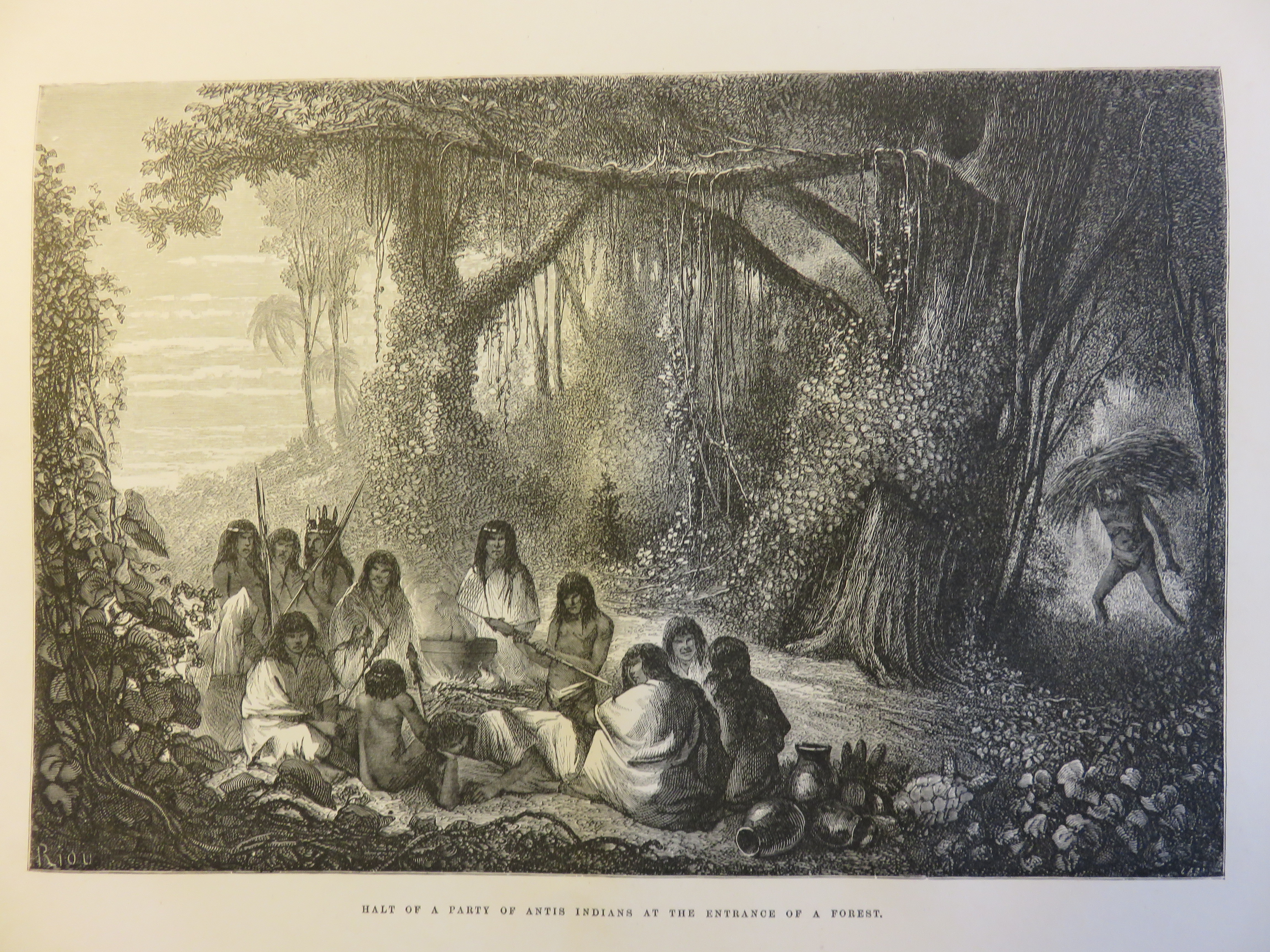
The Peruvian Amazon tribes described in his work included the Antis, Antihuaris, Chontaquiros, Pucapacuris, Conibos, Schetibos, Impétiniris, Sipibos, Panos, Sensi, Amahuaca, Chacaya, Cocamas, Omaguas, Iquitos, Ccotos, Anguteros, Yahua, Ticuna, and Marahua. For most ethnic groups Marcoy made portraits, and sketched some scenes of domestic lives, and he also drew and described examples of their manufactured implements. In addition, for some of the tribes he provides a list of translated words, and in some cases an outline of their religious practices. In many aspects the accounts of Marcoy seem to mirror the topics documented by Smyth and Lowe (1836). In both accounts, the importance of rum and mazato are emphasized, or in other words, there were a lot of drunkards in the 19th century.
It remains unclear about the motives for Marcoy’s journey, and whether or not his being appended to the Franco-Peruvian Rio Ucayali-Amazon exploratory trip was accidental or something that he learnt about and intentionally placed himself in a position to join them from their planned departure point. The expedition was woefully ill prepared, under equipped, and rather unorganized, relying on natives along the route for sustenance and assistance in transportation. Despite having the trappings of the late 19th century´s man of science, the relative contribution of Marcoy’s geographic and botanical descriptions and drawings remains questionable. It is unclear if any new species were documented through his work. Nonetheless, the illustrations make this work highly worthwhile for the reader to place oneself into the journey experience. Additionally, in this time there were limited maps about the Amazon River and its major branches, such as the work by Sobreviela in 1791 that was published in Lima’s Mercurio Peruano, and the college in Santa Rosa de Ocopa made a more detailed 1818 map of the Rio Ucayali and its missions (these map can be found online). Marcoy carried a copy of Sobreviela’s map on his trip, an admission that one does not learn about until page 262 of vol. III. Did the account by Smyth and Lowe (1836) travelling down the Rio Tambo-Ucayali-Amazon River, with a layover at Sarayacu, provide Marcoy the inspiration for making the trip? Their maps of the river system are far superior from those of Sobreviela’s.
Upon reaching Barra do Rio Negro Marcoy took a charter sailing vessel, a sloop, down the remainder of the river to the coast. From here his narrative is less under his control, and goes into more historical accounts of places that are passed along the river. He leaves this long remarkable journey after some city exploration of Santa Maria de Belen do Para and stated that he now intends to travel by ship to Buenos Aires, around to Chile to the Isla de Chiloe, and then return to Lima. He did make several trips to and from Peru and France between 1847 and 1874, and in the last ten years of his life from 1876 to 1887 he served as director of the Bordeaux botanical garden in his hometown. During the last leg of the journey down the Amazon River, Marcoy commented on the presence of a steamboat on the river; their introduction would soon come with the rubber industry boom and even faster rate of development and exploitations of many types.
One constant question while reading about this journey is whether or not anybody has recreated his route? While reading the account the places described were located in Google Earth; a list of GPS waypoints is listed below. The conditions and people in Peru have changed over the last 171 years, yet the landscape must surely be more fixed in terms of what such a trip would encompass. The mule trails and beer houses of old times are gone and paved to graded roads now cover much of his route to the headwaters of the Amazon River to the northeast of Cuzco. Today, in the Peruvian Andes, one has buses, rental cars, major hotels, upscale dining in Cusco, and once into the Amazon basin, wooden long boats with outboard motors regularly transit the rivers. Marcoy´s journey today would entail similar risks of petty theft, but also includes drug traffickers, and in the Andean foothills elements from the Peru’s failed violent uprising the Sendero Luminoso terrorist group. We ask ourselves, how many days would it take now to make Marcoy’s journey if following as close as possible his original route? Recreating the trip one would take the time to see some of the landscape and cultural sites described in his book, but use the current transport modes. The biggest question most will probably ponder while reading through Marcoy’s travel is whether or not one has the mental and physical capability or stamina to endure such hardships while in the oppressive hot humid climate dealing with 1846’s logistics? The fact remains that Paul Marcoy made the journey, taking one year and 14 days, and most of us have not, and probably will never do so, but for those wishing to recreate his route the following points of his trip are laid out for navigation.


Select Coordinates of Paul Marcoy’s Route (decimal degrees, lat./long.)
Most of these locations are places where Paul Marcoy spent the night, and sometimes weeks, during his journey. Some of the coordinates are approximate. This list is not complete, many locations he mentions were undeveloped and given local names of that time. He has also spent the night on various river islands; these names are mostly lost to history. Careful examination of the report by Carrasco (1846) would likely improve some of the layover-campsite locations during the expedition.
Coastal port of Ilay (location uncertain, present area of shipping port Matarani)
-17.006602, -72.108457
Arequipa
-16.398847, -71.536826
Lampa
-15.364093, -70.366709
Sicuani
-14.271922, -71.229277
Tinta
-14.146382, -71.403946
Acopia
-14.05999, -71.491983
Urcos
-13.689965, -71.624941
Cusco
-13.516616, -71.978789
Ollantay-Tampu
-13.259863, -72.263352
Occobamba
-12.871593, -72.447463
Echarati
-12.766379, -72.580067
Tunkini rapids (Pongo de Mainique)
-12.237026, -72.819889
Confluence of Urubamba and Rio Tambo (Apurimac); now with the town of Atalaya
-10.704438, -73.758408
Caco (Cacu) community
-9.371025, -74.22269
Confluence Rio Pachitea
-8.771065, -74.529939
Lost mission of Sarayacu– Marcoy marks its position 6 miles westward of Rio Ucayali; a place that once had 1,000 residents should be notable in air photos.
-6.848571, -75.170045 approximate location inland
Or -6.791126, -75.116337 this active settlement closer to the Ucayali?
Or -6.679062, -75.175737 farther north along the next stream going westward, which is a more likely fit with the mentioned inland route connecting to mission at Tierra Blanca
Mission Santa Catalina (location lost?); it was on the right side of the Ucayali between Sarayacu and Tierra Blanca.
Mission Tierra Blanca
-6.55598, -75.175818
Isla Omaguas– this is a major point bar with the island formed by a channel cut off. The location is approximate, no cultural disturbance of the site remains in the air photos.
-4.17391, -73.238733
Nauta- large town with road connection to Iquitos
-4.506894, -73.575303
From this point on, in Marcoy´s journey, a question of what distance can a canoe travel on the Amazon River in a day becomes relevant while looking at the list of places where Marcoy stayed the night. In general, the river flow rate varies from 1.5 to 7 km per hour, depending on if it is wet or dry season. A 12 hour day could translate into a travel distance of a canoe or other floating vessel on an average of 75 kilometers. Many of the reported layovers are of 150 km or greater distance. Not every night spent was documented in Marcoy’s account; time or days spent were rather poorly communicated in his trip description.
Rio Nanay confluence
-3.700613, -73.246499
Rio Napo confluence
-3.458368, -72.741254
Misión Pevas– now a small town, to the left side of the Amazon River
-3.320943, -71.861746
Cochiquinas– a very small town, now called San Jose de Cochiquinas, to the right side of the Amazon River
-3.882612, -71.453072
Caballo-cocha– small town with an airport
-3.907661, -70.517782
Loreto Mission– possible location of present day of the Colombian town of Puerto Narino
-3.783335, -70.364846
Tabatinga
-4.230419, -69.942804
confluence Rio Jandiatuba
-3.461579, -68.852448
Sao Pablo and Sao José do Matura
Tunantins
-2.864382, -67.774388
Isla Cacao
Rio Jutahy (Jutaí)
-2.746769, -66.784404
Fonteboa– noon time visit
-2.511120, -66.084341
Rio Jurua– camped along banks
-2.632244, -65.755183
Lago Preguica and Copaca plus Caycara/Rio Uraua- exploration or backwaters and rivers, names have likely changed.
Teffé/Lake Ega- now called Lago Tefé
-3.347220, -64.70991
Noguiera village
-3.301341, -64.780327
Rio Japura– Amazon branch, several days of exploration
-2.734767, -64.916377
Lake Juteca
-3.591945, -64.311802
Villa de Coary– now Coari, present population 82,000.
-4.085432, -63.13666
Rio Puras– several days of exploration, camped at the confluence
-3.686542, -61.467395
Barra do Rio Negro- Manaus, now population of two million, during Marcoy’s 15 day stay he reported a population of 3,000. Marcoy took a charter sail boat from here down the remainder of the trip to Para. In Brazil the local term for the Amazon River is Rio Solimoes.
-3.142062, -60.022113
Between these towns is about the upper limits of the Amazon River tidal bore, or Pororoca.
Obidos– stop over for provisions, sizeable town in 1870; present population of 49,000, located >570 km downstream from Barra do Rio Negro.
-1.919642, -55.513044
Obidos is near the upper limit of tidal effluence- the Amazon below here, can develop a tidal bore, a feature that Marcoy mentions at several points during his trip.
Santarem– town visit; the city has a population of 295,000 today.
-2.419354, -54.706119
Porto de Móz- small town
-1.754130, -52.240423
Gurupá– still a small town on the right bank
-1.407896, -51.649105
Canal de Bréves– long narrow channel, going through the town of Breves, connects to Canal Amapá
-1.053065, -51.020119
Santa Ana do Igarapé– inland town, connected by channels, a somewhat surprise route
-1.984098, -48.966833
Santa Maria de Belen do Para (Belem)- This was the ending point of Marcoy’s west to east journey across South America. This old port city now has a population of 1,439,561.
-1.462508, -48.505746
Citations
Bates, H.W., 1876, book review in the Academy (Robert Scott Walker publication, London), v. 7.
Carrasco, F., 1846, Vieje por los Rios Urubamba I Ucayali ejecutado de orden del gobierno del Perú por el Capitán de fragata Don Francisco Carrasco: in Larrabure I Correa, C., 1905, Colección de leyes, desretos, resoluciones i otro documentos oficiales referentes al Departamento de Loreto: Imprenta de La Opinion Nacional, num. 129, Lima, p. 149-176.
Castelnau, F., 1850, Expédition dans les parties centrales de l’Amérique du Sud : de Rio de Janeiro à Lima, et de Lima au Para: Bertrand, Paris, 7 volumes.
Raimondi, A., 1879, El Perú, v. III, Lima.
Smyth, W., and Lowe, F., 1836, Narrative of a Journey from Lima to Para; across the Andes and down the Amazon; undertaken with a view of ascertaining the practicability of a navigable communication with the Atlantic: John Murray, London, 293 p.
Do connect with us:
ResearchGate: James M. Wise
Author´s page: James M. Wise
Photography page: JamesM.Wise.com
Twitter: JamesM_Wise
Facebook: Yanira K. Wise
Author´s page: Yanira K. Wise
Instagram: yanirak.wise
Twitter: @YK_Wise
Facebook for South America to the World
Exploring South America’s inexhaustible creative force.


