PLAZAS DE ARMAS IN SOUTH AMERICA
Las Plazas de Armas or the town squares are the heart of South American cities. The seat of government, a church, or a meeting place. These public places embody the character of each city. They are a cookie cutter concept established by the Spanish explorers under the direction of the crown on how to establish a new city. And they vary in accommodating the landscape, and the decisions of government about the surrounding buildings’ functions. But it was always meant to be the city‘s main attraction. On this post we are sharing our impression of our visit to eight Capital cities in South America.
Bogota, Colombia-this is the second oldest plaza in South America. It was founded in 1538. The east side of the plaza has a nice stone wall cathedral, while all the other buildings surrounding the plaza have a blocky hideous appearing cement government buildings. And the plaza’s sides and streets are directed 45 degrees off of the north side. This is the third highest Capital Plaza at 2,616 meters above sea level. The town surrounding the plaza is known as La Candelaria.

Brasilia, Brazil– not Spanish, and not historic. The Capital city of Brazil was relocated and built from new in 1960. It does not feature a typical Plaza de Armas, but does have larger quadrangles and fields in between, many of them somewhat with awkward overly designed buildings. The city layout marks a crescent moon, board, wide, long arcing avenues. And the government complex has the largest open spaces of any place in South America. The main yard runs 20 degrees off of east-west in a direction with obscure rationale.

Buenos Aires, Argentina– the Plaza was originally founded in 1580, then the Plaza de Armas was widened in 1884. A place which is now called Plaza de Mayo. It is right in front of the Presidential Palace in Buenos Aires, but breaks in the traditional design elements by not having a cathedral facing the plaza. The Plaza del Congreso, located 10 blocks to the west, actually defines a nicer appearing plaza. Plaza de Mayo and Plaza del Congreso are both rectangular, longer in the east-west direction. Plaza de Mayo and city grid lies about two degrees west off of north-south.

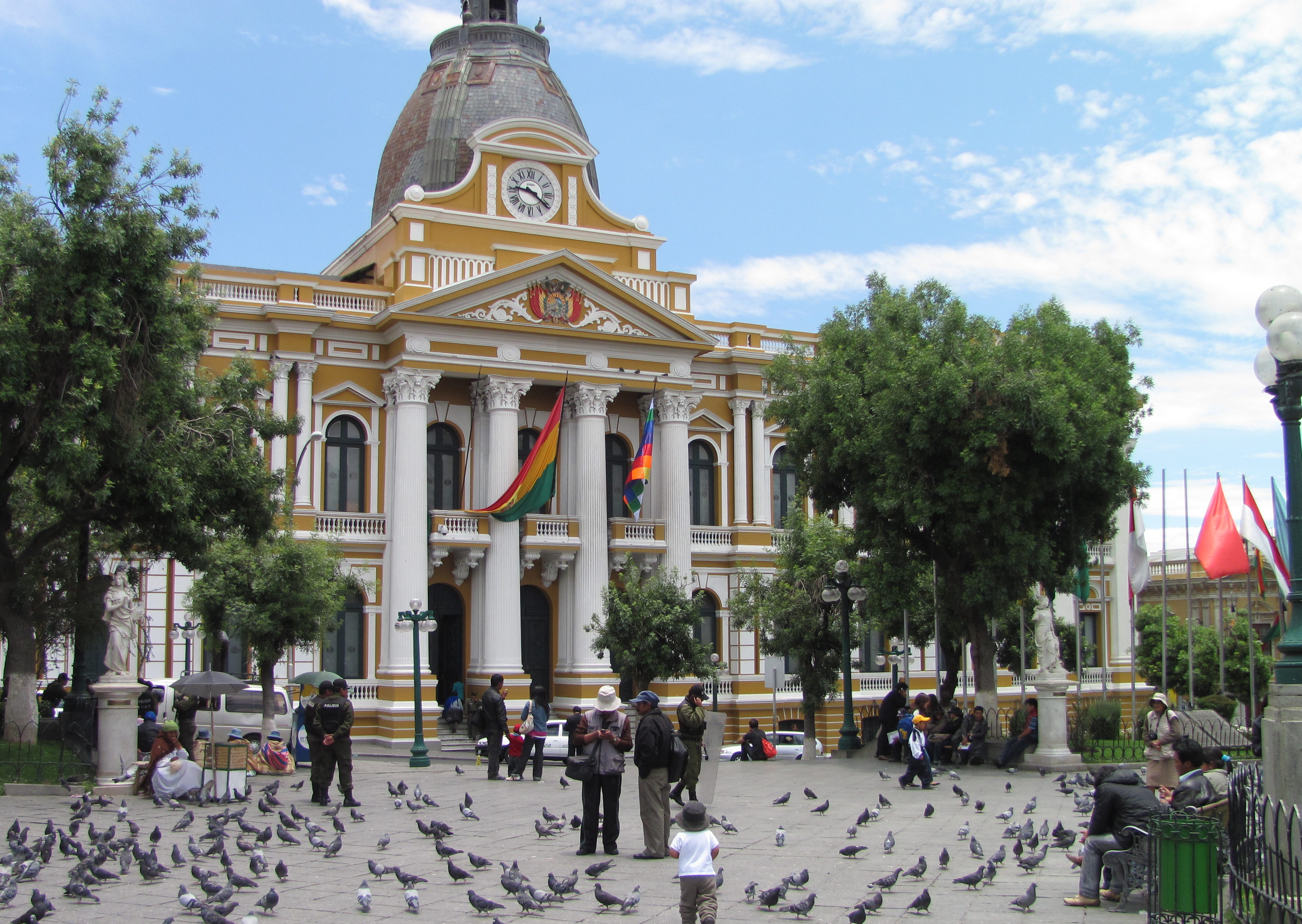
La Paz, Bolivia– this is the highest Capital Plaza de Armas in South America at 3,656 meters above sea level. The Plaza de Armas in La Paz was built-in 1558, relocating the city’s center from its original location that was first inhabited by the Spanish a couple of decades earlier. The Presidential Palace overlooks the Plaza from the east side. And the main cathedral borders the southwest side of the plaza. A new skyscraper is being built now one-block back to the south, it shadows the place and ruins the skyline view. The city grid lies off of the ordinates, such that one direction of streets runs straight down the valley slope towards the river.

Lima, Peru– the Plaza de Armas de Lima is also called the Plaza Mayor, dates back to the founding of the city by Francisco Pizarro in 1535. Lima’s plaza has buildings with distinct lattice and covered wooden balconies. The northeast corner facing towards the Rio Rímac has the Presidential Palace. The city blocks are oriented nearly at 45 degrees off from the north side.

Montevideo, Uruguay– is a newer Plaza de Armas, called the Plaza Independencia, was laid out in 1830, located somewhat east from the old town center, a place known as Casco Viejo. The plaza is rectangular shaped, elongate in the east-west direction. The street lay out is about three degrees west off of north.

Quito, Ecuador– also called Plaza de la Independencia, also known as Plaza Grande. This Plaza de Armas was established here in 1610. This is another plaza and street networks rotated about 45 degrees off from north, in a direction roughly parallel to the valley. The city has spread out along. Quito has South America’s second highest capital Plaza de Armas sitting at 2,218 meters above sea level.

Santiago, Chile– the Plaza de Armas was laid out in 1541 and has a cathedral along its west margin. A classic simple fountain in the center, the plaza is a popular gathering place. It is not to be confused with the Plaza de la Constitucion, which lies 4 blocks to the southwest at the Presidential palace. In Santiago de Chile the plaza and street layout comes in about 4 degrees west of north.

A common pattern from above looks at the city grids’ is that there are some near ordinate, 45 degrees askance. And those that are just plain catawampus. These can be sometimes being explained as with topographic control, or following a major river, as it has been done in Paris, and London. So many older cities just have a labyrinth of curvy ways. In contrast, Washington D.C. follows the ordinates with the National Mall running east-west. Lima being 45 degrees off of north is an odd choice given the broad plain. It was built on the space to do just about anything. It is surprising that the Río Rimac did not do more to influence the street directions. With military commanders establishing the older cities, and later, engineers making the street layouts, it is startling that more systematic directions were not adopted earlier. One advantage of not having the ordinate directions for streets is not having to deal with the sunrise and sunset glare while driving east-west streets. This was probably not so much a concern while guiding a horse drawn buggy.
Do connect with us:
ResearchGate: James M. Wise
Author´s page: James M. Wise
Photography page: JamesM.Wise.com
Author´s page: Yanira K. Wise
Remember: South America seems to refuse to show its inexhaustible creative force.


