MAJOR INFLECTIONS AND EROSION TRANSITIONS IN THE CANYONS OF THE PERUVIAN ANDES
Significant geomorphic contrasts exist across the two sides of the continental divide in Peru that are a consequence of dissimilar denudation and structural domains. The Amazon side receives more than 2-meters of annual precipitation whereas the Pacific slope and coast of Peru receive less than about 0.1 m. The western slope has relatively small catchment areas marked by dendritic drainage patterns; in contrast, the eastern side follows the structural fabric with semi-trellis form in much larger catchment areas (Fig. 1). Nonetheless, erosion of the Pacific slope during the Neogene produced deep valleys, the most extreme of which are the canyons of the Rios Colca and Cotahuasi north of Arequipa, which locally have about 3,000 m of relief. Interfluves cover a significant percentage of the Pacific slope, and head-ward erosion incompletely dissects the Cordillera Occidental and High Plateau Province. Large semi-confined canyon-mouth fans were formed along the coast during the Plio-Pleistocene. Possibly concurrent with fan deposition, the west-directed valley floors were aggraded up to an average elevation of about 1,800 m (Table 1). Subsequently, the alluvial fans and valley floors were incised, leaving a series of depositional river terraces. The elevation marking the change between bedrock and alluvial channel base averages about 1,000 m lower on the Amazon side of the Andes (Table 2). North-south variations in the elevation of the bedrock-alluvial channel transition highlight a uniform pattern for the east-directed canyons, whereas south of 11°S latitude the Pacific canyons may have been more affected by the subduction of the Nazca ridge. Higher discharges, despite the lower gradients, make the drainages on the eastern side of the Andes more effective in transport than along the Pacific slope.
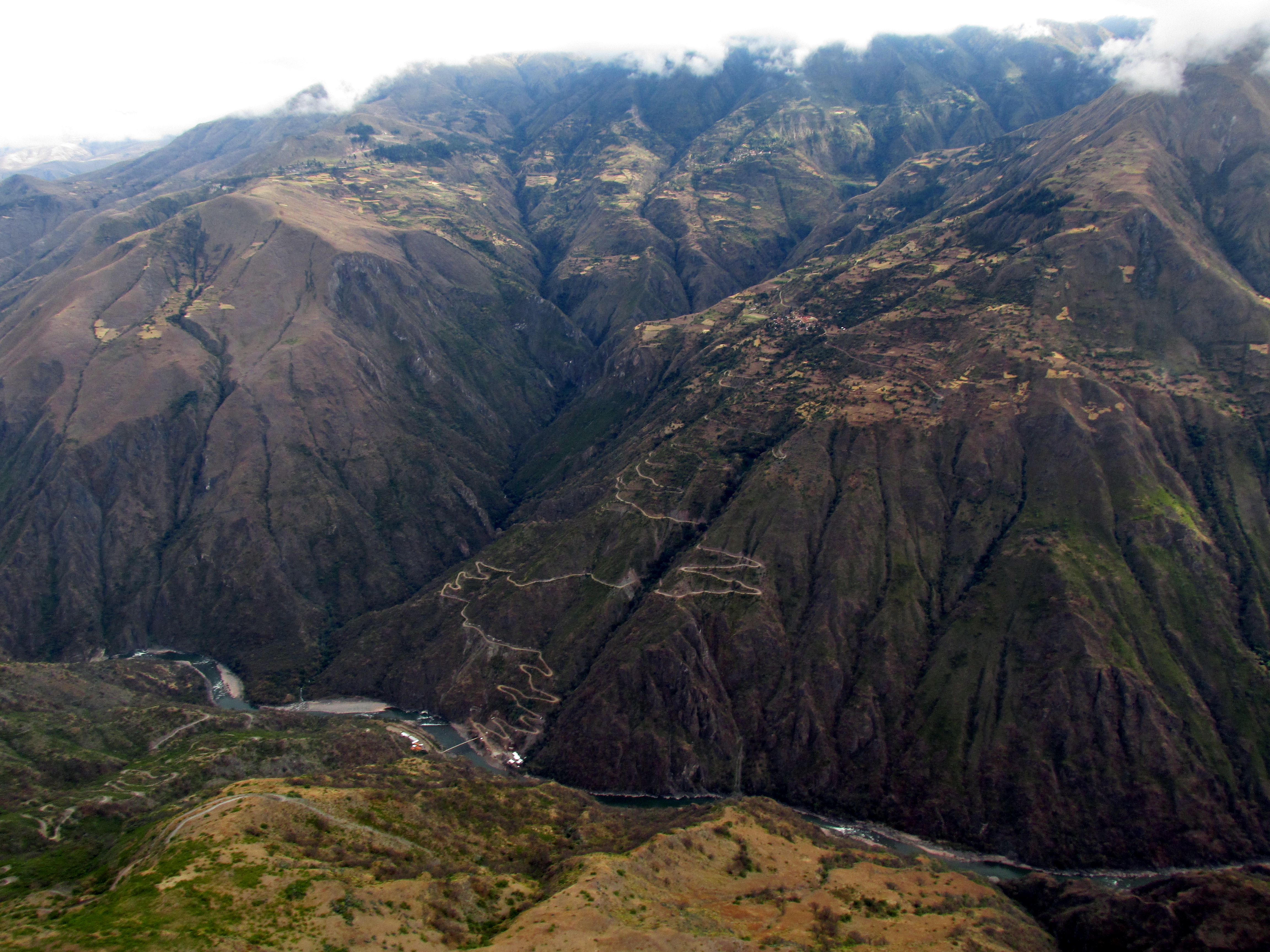
[The header image to this post is a photograph taken overlooking the Apurimac Canyon in southern Peru. The opposite canyon wall has upper lower-angle slopes whereas the inner canyon has steeper hill sides with about 730 meters of relief from the river bed to the slope transition. This canyon flows towards the Amazon basin. People tend to live above this transition line where some crops can be grown; below the transition erosion is too aggressive for terrace farms to remain stable.]

Figure 1. Generalized map of major rivers of Peru, showing location of the canyon profiles measured along Rio Mantaro, and Rios Cañete (C), San Juan (S), and Pisco (P) in slightly heavier line weight. Pacific flank of the continental divide has very short rivers that are directed westward, whereas the Amazon flank rivers have a trellis form that lies sub-parallel to the major structures of the Subandean zone. Also marked are Rio Urubamba (R), Colca canyon (CO), Huancayo (H), Lake Junin (J), and Lake Titicaca (T). Major summit groups are Huascarán (6768 m) of the Cordillera Blanca (HN); Nevada Yerupajá (6634 m) in the Cordillera Huayhuash (Y); Nevada Huaytapallana (5557 m) east of Huancayo (H); the Cordillera Pishcahuijpa (~5900 m) north of pueblo Yauyos (CP); Nevado Ausangate (6384 m) of the Cordillera Vilcanota near Cuzco (A); and Nevado Salcantay (6271 m) of the Cordillera Vilcabamaba.


Pacific flank canyons
West-directed drainages of central Peru form concave-up, or graded, river profiles (Fig. 2 and Table 1). Above approximately 1,800±700 m the canyon profiles are steeper and bedrock is being eroded. The upper reaches decrease in gradient, passing into glaciated valleys above about 4,000 m elevation. In the lower parts of the canyons, where the river slope decreases, the valley floors become wider and flat, lined by boulders, and the rivers take on a braided pattern, although still confined by the canyon walls. The gravel and boulders lining the canyon floors represent aggradation, which happens when deposition exceeds the river’s capacity to transport the bed load. The upper segments of the west-draining rivers in the Cordillera Occidental make slopes of 5 to 15 percent and the slopes in the lower parts of the rivers are around 2 to 3 percent. Large alluvial fans at the confluence of the tributary canyons are present along the wider sections of the trunk canyons. There are about twenty major rivers on the Pacific flank of the Andes with year-round discharge. Many of the smaller drainages have intermittent flow, although large boulders in the channels indicate much higher past discharge, which in many cases comes from flash floods.

Figure 2. Comparison of river profiles from the Pacific and Atlantic flanks of the central Peruvian Andes. A. Rio Mantaro river profile and the location of major intermontane basins, B. stream indices of the Rio Mantaro, and C. The Pacific flank rivers have a graded profile.
Amazon flank canyons
Major rivers, such as the Rio Urubamba, have carved spectacular canyons where they transverse the Cordillera Oriental. Multiple slope angles, in places apparent in cross profile, imply increasing rates of incision (e.g., Garner, 1959; his Fig. 8). Steep inner gorge are present along the canyon near Tingomaria that cuts across the Cordillera Oriental. The drainage divides in the Cordillera Oriental and Sub-Andean belt are characterized by steep slopes and sharp crests, readily observed in areas such as Machu Picchu and Cobriza. The extremely narrow gorges indicate more rapid latest Neogene uplift and erosion along the eastern margin of the Cordillera Oriental than in the Cordillera Occidental, although Garner (1959) suggested major climate change was an important factor.
The Rio Mantaro profile was drawn from its source at Lago Junín, using topographic data from 1:100,000 scale maps (Fig. 2), to the confluence with Río Ene, which is a strongly meandering major tributary to the Amazon river at the base of the Andes. The Rio Mantaro is highly sinuous on a large-scale, and for much of its course flows sub-parallel to the NNW-trending sub-ranges. It is one the few rivers that drain several major intermontane basins. Many rivers develop a concave-upwards profile when at equilibrium with sediment input, uplift, and erosion. The Rio Mantaro exhibits the opposite pattern, suggesting disequilibrium such that erosion probably has not kept pace with uplift (Fig. 2). Slopes of Rio Mantaro are mostly below one percent. At the Ayacucho and Huancayo intermontane basins the river’s base is a braided alluvial channel running at slopes between 0.4 and 0.6 percent. The channel is eroding bedrock between these two basins and has a greater slope. Downstream from Ayacucho, where the river crosses the sub-Andean fold and thrust belt, pronounced local changes in slope probably reflect active faulting. The lowermost reach of the river, at about 550 m elevation, returns to an alluvial channel of lower gradient. Along both the Huancayo and Ayacucho intermontane basins, the river is bordered by a series of at least three major depositional river terraces that indicate the Recent incision of the thickly aggraded flood plains.
Below where the Rio Mantaro crosses the Ayacucho intermontane basin it has cut a deep valley across the Cordillera Oriental. Three cross-valley topographic profiles did not reveal stair-stepped Strath terraces. However, the valley walls are mainly cut into argillite of upper Paleozoic formations, which shed talus that drapes the hill slope. This exit location is also critical because in the Ayacucho basin late Pliocene lacustrine deposits lie on either side of the river at about 500 m above the current river channel (Wise and Noble, 2008). This not only places a limit on down cutting, but also implies that the Rio Mantaro did not contribute significant amounts of detritus to the generally fine-grained deposits. That being the case, the across range incision of the Cordillera Oriental by the Rio Mantaro perhaps occurred largely after the late Pliocene. East-side canyon transitions between alluvial river beds to bedrock eroding are far lower than along the west-side of the Andes (Table 2).
CANYON SLOPES HAVE MARKED ANGLE CHANGE
Across most canyons in the Peruvian Andes one can appreciate the upper canyon walls have lesser slope angles than the lower canyon walls (Fig. 3). Garner (1959) described the steep inner canyons as marking an increase in erosional incision, which he explained as a result of climate change. This marked transition in many canyons upper-middle sections lies 400 to 750 meters above the present canyon floor, and therefore is likely a feature that formed a couple million years ago rather than something that developed in the last tens of thousands of years. If this is the case, one may expect the feature to be evident in the fission-track exhumation data sets and calculated rock erosion rates, however all such studies done to date in Peru (Garver et al., 2005, Wipf, 2006, Thouret et al., 2007, Schildgen et al., 2007, Gunnell et al., 2010, Margirier et al., 2015, Michalak et al., 2015, Scherrenberg et al., 2016) do not mention this geomorphic feature nor list Garner’s study in their citations. The timing of this slope transition during erosion of the Peruvian Andes remains unknown.

Figure 3. Photograph on the tributary canyon wall near Churin showing the significant change in slope (marked at the yellow line). Part of the canyon walls have additional degradation through landslides. Area above the yellow line has lower slopes and more rounded forms whereas below the yellow line the canyon wall is steeper and the land surface more regular from recent rapid down-cutting. This is a Pacific flowing drainage.
DISCUSSION
The oblique subduction of the Nazca ridge, a major thicker volcanic belt formed on the oceanic plate, appears to have made a subtle, but detectable, north-south variation in the alluvium-bedrock transition of major rivers along the Pacific flank of the Peruvian Andes. The center line of the ridge impinges upon the trench at latitude 15 degrees south, which is about 360-km south of Lima. One readily observable consequence of the ridge subduction is exhumed forearc sedimentary formations of the Pisco basin. Wipf (2006) attempted to measure the influence of the subducting ridge by rock exhumation studies using the fission-track method from transect both north and south of Pisco, resulting unclear thermal estimates for likely a variety of contextual problems. My study takes more directly geological and geomorphic set of observations to describe what the impacts were from ridge subduction.
The subduction of the nearly 2,000-meter thick Nazca ridge has produced distal geomorphic effects including depositional-erosional signatures in the major river channels, and preservation of volcanic cover along the western slope of the Andes. The elevation of aggraded river bases to bedrock erosion transition varies systematically along the Pacific flank, increasing as it approaches the Nazca ridge. Post-Eocene gently westward-tilting of the Pacific slope affected erosion surfaces that developed between the Eocene (Noble et al., 1978) and late Miocene time (Tosdal et al., 1984). Increased erosion of these mantling deposits is noted to the north of the Nazca ridge, which indicates the canyon geomorphology is also likely impacted.
To my knowledge, this is the first time anybody has looked at the systematic variation in river aggradation levels in Peru. The Pacific flank canyons generally lie in a major structural domain underlain by the rigid Coastal Batholith Block (Wise et al., 2014) whereas the Amazon flank canyons are in a domain of more mobile geology related to the exhumation of the Precambrian rocks in the Cordillera Oriental and the domain of active deformation in the foreland fold and thrust belt going into the Andean foothills. The Amazon flank canyons need additional data points to the south to confirm if the Nazca ridge is not influencing the aggradation-bedrock erosion elevations. With these canyons being in an areas of significantly higher rainfall and more mobile geology it is possible that the Nazca ridge has not played a role in the geomorphology of the Amazon flank. In addition, the Amazon flank is further inboard so any influence would likely be less than along the Pacific flank of the Andes. The Pacific flank may be showing greater deviation of this transition because of lying in a less dynamic and slower eroding domain.
I have brought up the issue of the steep inner canyons that Garner (1959) described as a side issue on the canyon geomorphology- the aggradation-bedrock erosion transition elevations is something that formed well after the change in erosion rates that produced the different canyon wall slopes. It is worth noting because it is geological evidence of variable erosion rates through time. The above outlined contrasts between the Pacific and Amazon flanks of the Andes also points to variable erosion and uplift rates across the Andes- defining a singular or average rate of Andean uplift is probably meaningless.

Figure 4. Graph comparing east- versus west-draining bedrock-alluvium channel transition elevations for Peru. Shaded bar shows the latitude of the Nazca ridge. Open triangles the transition was directly observed in the field. Solid circles the top of aggraded valleys, taken as the transition to river eroding the bedrock, was measured from INGEMMET geological maps.
References
Garner, H.F., 1959, Stratigraphic-sedimentary significance of contemporary climate and relief in four regions of the Andes mountains: Geol. Soc. Am. Bull., 70, 1327-1368.
Garver, J.I., Reiners, P.W., Walker, L.J., Ramage, J.M., and Perry, S.E., 2005, Implications for timing of Andean uplift from thermal resetting of radiation-damaged zircon in the Cordillera Huayhuash, Northern Peru: Journal of Geology, v. 113, p. 117-138.
Gunnell, Y., Thouret, J-C., Brichau, S., Carter, A., and Gallagher, K., 2010, Low-temperature thermochronology in the Peruvian Central Andes: implications for long-term continental denudation, timing of plateau uplift, canyon incision and lithosphere dynamics: Journal of the Geological Society, London, V. 167, 2010, p. 803-815.
Margirier, A., Robert, X., Audin, L, Gautheron, C., Bernet, M., Hall, S., and Simon-Labric, T., 2015, Slab flattening, magmatism, and surface uplift in the Cordillera Occidental (northern Peru): Geology, v. 43, p. 1031-1034.
Michalak, M., 2013, Exhumation of the Peruvian Andes: Insights from mineral chronometers: unpublished dissertation, University California, Santa Cruz, 177 p.
Myers, J.S., 1976, Erosion surfaces and ignimbrite eruption, measures of Andean uplift in northern Peru: Geol. Jour., 11, 29-44.
Noble, D.C., McKee, E.H., and Mégard, F., 1978, Eocene uplift and unroofing of the coastal batholith near Lima, central Peru: J. Geology, 86, 403-405.
Scherrenberg, A.F., Kohn, B.P, Holcombe, R.J., and Rosenbaum, G., 2016, Thermotectonic history of the Maranon fold-thrust belt, Peru: insights into mineralization in an evolving orogeny: Tectonophysics, v. 667, p. 16-36.
Schildgen, T.G., Hodges, K.V., Whipple, K.X., Reiners P.W., and Pringle, M.S., 2007, Uplift of the western margin of the Andean plateau revealed from canyon incision history, southern Peru: Geology, v. 35, p. 523-526.
Thouret, J.,-C., Worner, G., Gunnell, Y., Singer, B., Zhang, X., and Souriot, T., 2007, Geochronologic and stratigraphic constraints on canyon incision and Miocene uplift of the Central Andes in Peru: Earth and Planetary Science Letters, v. 263, p. 151-166.
Tosdal, R.M., Clark, A.H., and Farrar, E., 1984, Cenozoic polyphase landscape and tectonic evolution of the Cordillera Occidental, southernmost Peru: Geol. Soc. Am. Bull., 95, 1318-1332.
Wise, J.M., Noble, D.C., Vidal C.E., and Angeles Z., C., 2014, Structural and stratigraphic relations between the rigid Coastal Batholith Block and the Highland Mobile Belt and their relation through time to magmatism and caldera formation: Sociedad Geológical del Perú, XVII Congreso Nacional de Geológia, Resumes Extendidos, 6 p.
Wise, J.M., and Noble, D.C., 2008, Late Pliocene inception of external drainage and erosion of intermontane basins in the highlands of central Peru: Revista de la Sociedad Geologica del España, v. 21 (1-2), p. 73-91.
Wipf, M., 2006, Evolution of the Western Cordillera and coastal margin of Peru: evidence from low-temperature thermochronology and geomorphology: unpublished Ph.D. dissertation, Eidgenossische Technische Hochschule Zurich, 152 p.
Do connect with us:
ResearchGate: James M. Wise
Author´s page: James M. Wise
Photography page: JamesM.Wise.com
Author´s page: Yanira K. Wise
South America seems to refuse to show its inexhaustible creative force.


